Agenda item
BROMLEY'S LOCAL PLAN - POTENTIAL SITE ALLOCATIONS DRAFT POLICY AND DESIGNATIONS ALTERATIONS' FOR CONSULTATION
- Meeting of Development Control Committee, Monday 13 July 2015 7.30 pm (Item 24.)
- View the background to item 24.
(A copy of the ‘Local Plan – Potential Sites, Draft Policy and Designation Alterations’ referred to as Appendix 1, will be made available in the Members’ Room and published on the Council’s website shortly. A paper copy will also be available at the meeting.)
Minutes:
Report DRR15/070
Members were requested to endorse Appendix 1 as the consultative ‘Local Plan – Potential Sites, Draft Policy and Designation Alterations’ stage in the preparation of Bromley’s Local Plan. Members were also asked to refer the document to the executive for approval for the purpose of consultation with residents, partner organisations and the wider community.
The Chairman reported that progress in drafting the Local Plan had been reviewed by the Local Development Framework Advisory Panel. The Potential Sites, Draft Policy and Designation Alterations’ stage focussed on designating sites in Wards for particular purposes. The latest updates incorporated an increased housing target of 641 units; minimal parking provision and variations to the Biggin Hill SOLDC.
The following comments were made:-
• Living in Bromley (page 135) - the first sentence within the coloured table should read 'The Council will make provision for at least 641 additional homes per annum over the fifteen year Plan period which will be facilitated by: ….'.
• Getting Around (page 136) - with regard to the provision of off-street parking for 1-2 bedroom accommodation, clarification was sought on what constituted 0.7 space.
• Safeguarding land for transport investment (page 136) - One Member was pleased to note the Council's proposal to explore with TfL the potential for improvements at the junction of the A232 Croydon Road and the A233 Westerham Road and Oakley Road as currently this was an extremely precarious junction. Feedback on progress achieved in this matter was requested.
• Potential Draft Site Allocations and Designations (Table 1 - page 139) - One Member was unhappy with the proposal to redesignate land at Turpington Lane for educational use due to the winding nature of the surrounding roads and the inability to prevent vehicles from speeding.
• Potential Draft Site Allocations and Designations (Table 1 - page 140) - The Maybury Works in Worsley Bridge Road was currently industrial, commercial and employment use. The former Dylon site located adjacent to this had been designated for commercial use. Redesignating The Maybury Works to mixed residential would result in an over-intensive use and a request to retain its current designation was requested. Members were informed that retaining the site's current designation would be difficult because whilst it provided employment for 40-60 people, approximately one third of the site remained unused.
• Potential Draft Site Allocations and Designations (Table 1 - page 140) - in regard to Bromley Civic Centre, the words "and other town centre uses" was vague and should be clarified.
• Potential Draft Site Allocations and Designations (Table 1 - page 141) - One Member opposed the expansion of the site at Higham Hill Farm, Layhams Road, Keston. The land was used as a buffer between the road and the showman's site. A long-term strategy was required to locate plots elsewhere.
• School sites should be safeguarded and one Member asked whether this could be done at the determination stage of an application. The Chairman reported the Education Department considered it necessary to redesignate now to present less difficulty in future consideration of applications. It was also incumbent upon the Council to identify and adopt land for educational use. It was noted that if the Council identified enough sites, then applications submitted from elsewhere could be turned down at determination stage.
• Table 2 - Sites not recommended for housing/mixed use allocations (page 143) - A proposal for high density housing at Potters Yard, Turpington Lane was recently refused. An appeal had been submitted for which a decision was yet to be made.
• Members were informed that the redesignation of various schools from Green Belt to Urban Open Space would make it easier in the future for land to be used for education purposes.
• One Member was uncomfortable with the development proposals at Biggin Hill Airport and the removal of Green Belt land from what was an important historical site. The developers had asked for more land to be redesignated than that already included within the consultation document. There was concern that agricultural land next to the site would be used for development purposes; Members were assured that the SOLDC boundary would remain the same and the quality of the environment would be retained.
• It was agreed that Tree Preservation Orders be placed on trees at the Biggin Hill site. The Chief Planner confirmed that provisos would be implemented in relation to re-planting.
• In regard to parking (page 73, paragraph 5), it was noted that three areas had been identified where lower minimum parking standards than the rest of the borough would be appropriate given their higher level of public transport accessibility. Despite this, there was a very high density of housing in these areas and the majority of residents owned cars.
The following officer updates and clarifications were circulated to Members (revised text in italics): -
‘Appendix One - Draft Consultation Document (pages 23-24)
Show as a Policy/Proposal. Insert at the top of page 24 ‘The following sites are proposed as allocations for consultation purposes:-’ (list as in Appendix One p.24 then follows)
Page 24
After ‘Site Assessment 2015’ (at the foot of the page) insert ‘which is enclosed as Additional Document B. The Broad Locations for growth in the later stages of the Plan are identified mainly due to Opportunity Area, Town Centre and/or Renewal Area status’.
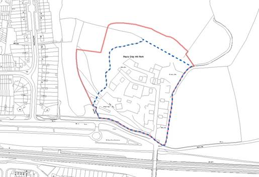
Page 34
Amend Traveller site boundary Map 1 Star Lane (below). The amended site boundary (blue hatched line) limits the site to the extent of existing traveller pitches. The red line, in the DC report, predominantly followed physical features (escarpment/earth bunds).
Page 47/48
Show as a Policy/Proposal: ‘In conclusion, the sites that comprise Table 7 which are set out in full at Appendix 3 (p62-66) are draft allocations and proposals for consultation purposes. All are subject to their being supported by the necessary site specific infrastructure’.
The recommendations set out on page 130 of the report were amended to read (amendments in bold):-
‘That development Control Committee:
2.1 Endorse Appendix 1 as the Local Plan, potential sites, draft policy and designation alterations document for the executive to agree for public consultation.
That the Executive:
2.2 Consider the comments from DCC with regard to the Local Plan – potential sites, draft policy and designations alterations, and
2.3 Approve Appendix 1 as the Local Plan – potential sites, draft policy and designations alterations, document for public consultation, together with any agreed amendments, subject to the Director of Regeneration & Transformation, in consultation with the Chairman , being authorised to make any minor alterations to the document as required, and agree the final supporting documents prior to the publication.
RESOLVED that subject to the amendments set out above, Appendix 1 be endorsed as the ‘Local Plan – Potential Sites, Draft Policy and Designation Alterations’ document for the Executive to agree for public consultation.
Supporting documents:
-
DCC 130715 - Potential site allocations, item 24.
 PDF 577 KB
 -
Appendix 1 Part 1, item 24.
PDF 3 MB
-
Appendix 1 Part 2, item 24.
PDF 5 MB
-
Appendix 1 Part 3, item 24.
PDF 6 MB
-
Appendix 1 Additional Document A, item 24.
PDF 112 KB
-
Appendix 1 SINC 1 Appendix 1 - Title Sheet, item 24.
PDF 7 KB
-
Appendix 1 SINC 2 Appendix 1 - Schedule of Sites PDF, item 24.
PDF 69 KB
-
Appendix 1 SINC 3 Appendix 1 - Schedule of Sites Excel, item 24.
PDF 70 KB
-
Appendix 1 SINC 4 Appendix 2 - Title Sheet, item 24.
PDF 7 KB
-
Appendix 1 SINC 5 Appendix 2 - Keys to Page Locations, item 24.
PDF 4 MB
-
Appendix 1 SINC 6 Appendix 3 - Title Sheet, item 24.
PDF 7 KB
-
Appendix 1 SINC 7 Appendix 3 - Pages 1-3, item 24.
PDF 930 KB
-
Appendix 1 SINC 8 Appendix 3 - Pages 4-7, item 24.
PDF 1 MB
-
Appendix 1 SINC 9 Appendix 3 - Pages 8-12, item 24.
PDF 1 MB
-
Appendix 1 SINC 10 Appendix 3 - Pages 13-15, item 24.
PDF 1008 KB
-
Appendix 1 SINC 11 Appendix 3 - Pages 16-20, item 24.
PDF 1 MB
-
Appendix 1 SINC 12 Appendix 3 - Pages 21-25, item 24.
PDF 1 MB
-
Appendix 1 SINC 13 Appendix 3 - Pages 26-30, item 24.
PDF 1 MB
-
Appendix 1 SINC14 Appendix 3 - Pages 31-34, item 24.
PDF 1 MB
-
Appendix 1 SINC15 Appendix 3 - Pages 35-37, item 24.
PDF 888 KB
-
Appendix 1 Additional Document B, item 24.
PDF 21 MB